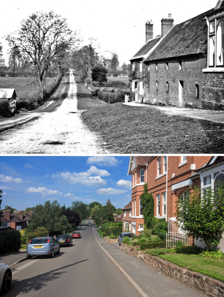
This early photo of the southern end of Malthouse Lane is notable for two reasons. Firstly, it shows the road as a rural lane, surrounded by fields, long before the modern housing estates built in the 1950s and 1960s existed. Secondly, it also shows the actual Malt House, which gives the road its name.
Today, the building known as the Malt House is a grand Victorian house but the ‘then’ image above shows its predecessor, which was of course a functional building for the production of malted barley. According to Wikipedia, “A malt house, or maltings, is a building where cereal grain is converted into malt by soaking it in water, allowing it to sprout and then drying it to stop further growth. The malt is used in brewing beer, whisky and in certain foods”.
Regular readers may remember that we featured a later version of this same view in a Then & Now back in January 2016, in which the old Malt House had been replaced by the grand house we see today.
Our ever reliable resource A Portrait of Kenilworth in Street Names (Third Edition, Rookfield Publications, 2015) by Robin D Leach and Geoff Hilton tells us that the lane and its surrounding agricultural fields were first laid out following the inclosure awards of 1756, initially called Quarry Lane, presumably in relation to the nearby sandstone quarries occupied by what is nowadays called Quarry Cottage (distant left) and two more quarries on Berkeley Road (out of picture, right).
Tucked away behind the Malthouse itself is the maltser’s cottage, which survives the actual malt house itself, now known as Castle Hill Cottage (no. 8 Malthouse Lane). Next is the site of the actual Malt House (no. 6 Malthouse Lane). In the foreground the grand bay window of the neighbouring property, now known as The Quarry (no. 4 Malthouse Lane). Perhaps surprisingly, none of this grouping appears to be listed.
Also of note, is how the lane has been widened for traffic, necessitating the loss of the sloping grass verges and the raised pavement used to access the properties in the ‘then’ image.