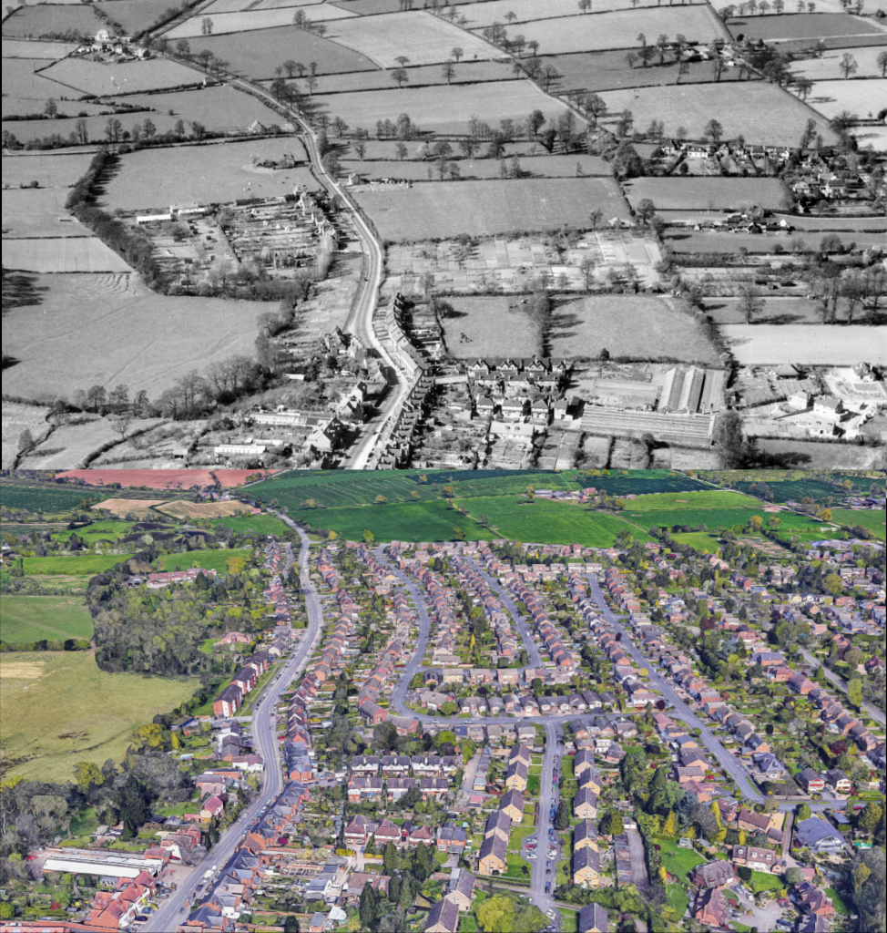
This Then & Now comparison shows the area now occupied by the Priorsfield housing estate, bordered by Clinton Lane (left), Beehive Hill (top), Malthouse Lane (right) and Castle Green (out of shot, bottom). The ‘then’ image is cropped from the 1953 aerial photo EAW048847 from the Britain from Above website, principally of the Castle to the south, but for our purposes it is the lesser photographed area to its north that we’re interested in here. The ‘now’ image is taken from Google Maps 3D photogrammetry view.
In 1953, the area between Clinton Lane and Malthouse Lane was mostly just a patchwork of fields, including the site of the old Castle Nurseries, whose glasshouses are visible (bottom right of the ‘then’ image), the site of which is now occupied by Denton Close. Much of the area shown has since been infilled with the likes of Priorsfield Road, Quarry Road, Grange Avenue, Woodcote Avenue, De Montfort Road, Denton Close and Cobbs Road, built in the 1950s and 1960s. In the bottom right of the ‘then’ image we can see the first two houses built on the corner of the as-yet truncated De Montfort Road, which was established in the year the ‘then’ photograph was taken and subsequently extended to its current extent.
It’s interesting to pick out some features in the ’then’ image, which you won’t see photographed elsewhere. To aid us in picking these out, we can use the, more or less, exactly contemporary OS 1:10,560 (1949 – 1970) map, which shows the area prior to development. For example, we can just about pick out a house marked as ‘Oakley’ on the map (top left of the ‘then’ image, in the field today occupied by Priorsfield School), which stood somewhere roundabout where 185 – 187 Clinton Lane now stands, on what became the western side of the 1960s Clinton Lane layby. Across the road, on the eastern side of Clinton Lane, another tiny spec of a house is visible. Neither house exists today.
In the very centre of the ‘then’ image we can see the numerous individual plots marked on the OS map link above as ‘Allotment Gardens’. Also, in the centre-right of the ‘then’ image we can see the cluster of buildings comprising Malthouse Farm, standing alone surrounded by its fields. Incredibly, the farmhouse survives today as number 10 Grange Avenue. Just behind it is Quarry Cottage, which also survives today, sunk down into the former quarry pit from which it, and nearby Quarry Road, get their name.
One of our KHAS members has documentation relating to the purchase of a plot of land immediately north of the Allotment Gardens, bought from Malthouse Farm by Warwickshire County Council for the purpose of building a pair of Police houses, with an office in between; now numbers 152 and 154 Clinton Lane. Although the compulsory purchase order is dated 1952, the actual conveyance is dated 6th August 1954.
