In April 2020 we were contacted by Steve Webster of Nelson, New Zealand, regarding a number of photographs from the collection of his late father, John Webster. Steve told us “My late Father John Webster lived in Kenilworth at 40 Tainters Hill (The Cottage) from birth, in 1927 and I too was born in the same cottage in 1961. My Family Lived in the Cottage until 1986 and Mother, Nona, (91) still lives in the town. John was a self employed Aircraft Radio Engineer, a Flying Instructor, with his own light aircraft that was kept at Coventry Airport. He also had a passion for photography, with his own dark room in Tainters Hill, that I grew up with”.

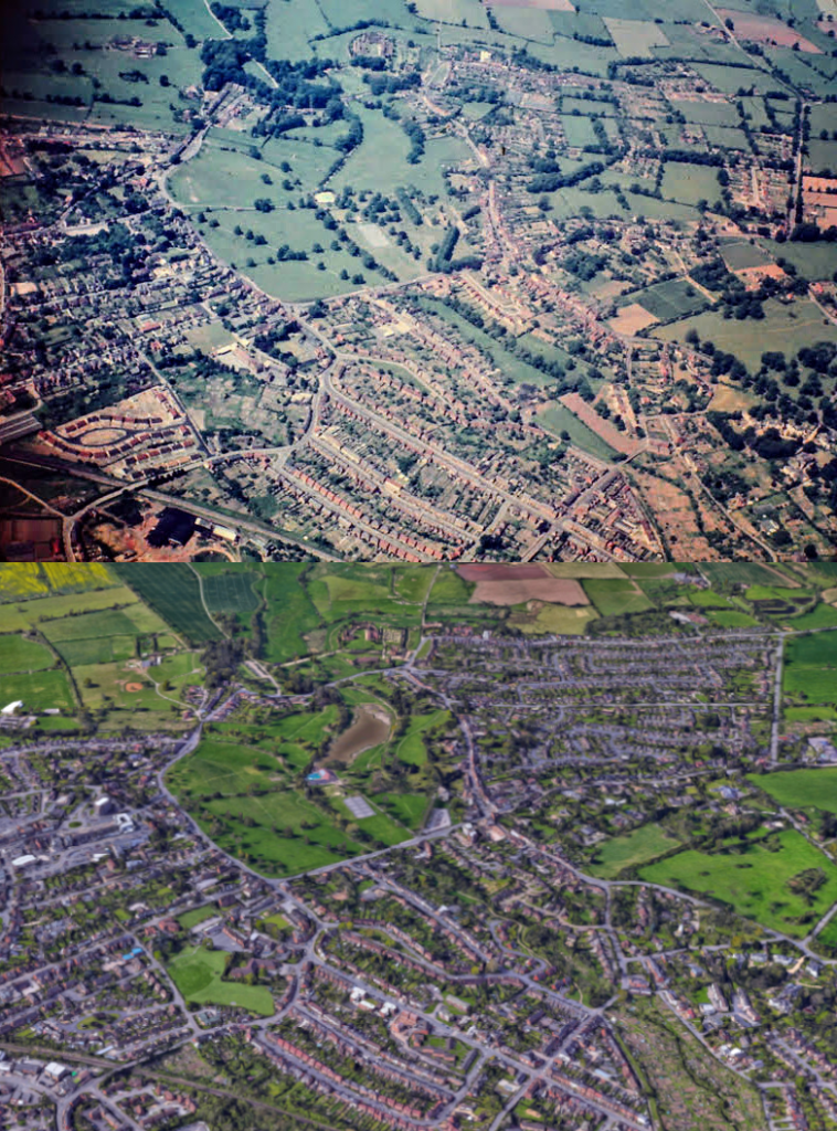
Steve has passed on a number of photographs from his father’s collection, including the remarkable aerial ‘then’ image above, which captures a number of features in the town which would be swept away or substantially altered over the subsequent decades. The aerial ‘then’ photo was taken from somewhere over the eastern edge of the town looking almost due west. The ‘now’ image is taken once again from the 3D photogrammetry view on Google Maps.
Given that the construction of De Montfort Road has been started but not finished on the ‘then’ image, it must be no earlier than 1953. Interestingly, Amherst Road looks to have been built up to the mini roundabout at its north-eastern corner, but not yet connected all the way through to the later Berkeley Road. Having consulted A Portrait of Kenilworth in Street Names (Rookfield Publications, 2015) by Robin D. Leach & Geoff Hilton it dates Amherst Road as 1963 and Berkeley Road as 1965 but one wonders if the northern bit of Amherst Road might have been established slightly earlier, as the houses at that end of the road do seem earlier in style than that of the rest of the street.
In the centre of the image we can see the Abbey Fields, featuring the old swimming pool, and the lake is yet to be permanently reinstated. In the bottom left of the image, the very recognisable teardrop shape of Offa Drive looks to have been newly laid out. Again, the ever reliable A Portrait of Kenilworth in Street Names suggests a date for the image to around 1961, before which the site was Henry Whateley’s plant nurseries. In the foreground (extreme bottom left of the ‘then’ image) is the disturbed ground of the old Cherry Orchard and Whitemoor brick works, either side of Whitemoor Road.
In the mid-left area of the image you can see the wedge shape of land between Abbey End and Smalley Place, in the middle of which the De Montfort Hotel (now Holiday Inn) would later be built, opening in 1967. Robin Leach has also added some further observations of “the bomb-flattened area at Abbey End, then a car park, now shops; the football pitch in the Abbey Fields behind the war memorial; and it looks like the large field adjacent to St Nicholas School has yet to become its playing field and is still privately owned (I think by the Stickleys)”. So, it’s a remarkable aerial colour image of an area in the process of undergoing a dramatic transformation.
We’d like to thank Steve Webster for providing this image, and many others, for us to use. Also, thanks to Robin Leach for adding his observations.
