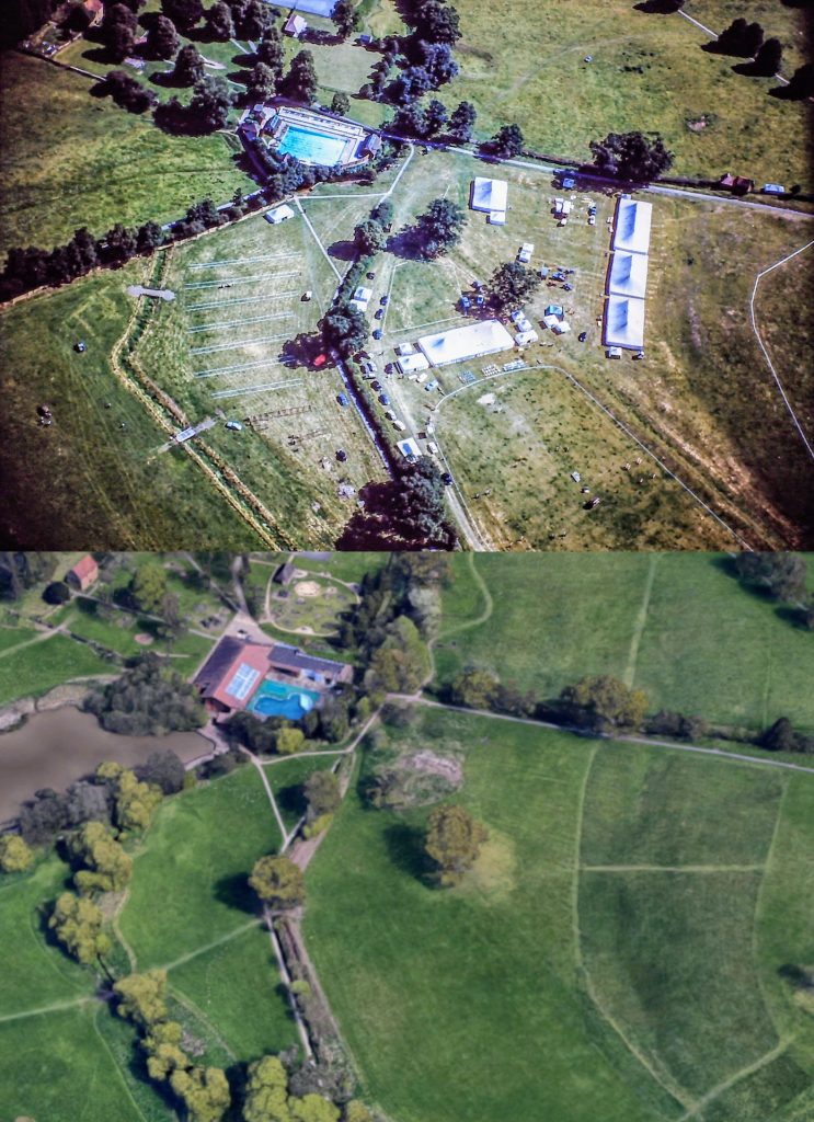
The photo above comes once again from the aerial imagery snapped by the late John Webster, kindly provided to us by his son Steve Webster, now living in New Zealand. This fantastic image shows the old Abbey Fields swimming pool as it appeared up until its redevelopment in the 1980s. The ‘now’ image is taken once again from the 3D photogrammetry view on Google Maps.
The Swimming Pool was redeveloped in 1985 – 1986, when the north-western end of the old outdoor lido was covered over to become a heated indoor pool. The old terracing and changing room block on the north-eastern side were incorporated into the new structure but much of the rest of the structure was substantially altered. A distinctive white waterfall feature on the south-western side of the lido, part of the pool’s filtration system, was not incorporated into the 1985 design. At the time of writing, the swimming pool is once again on the brink of redevelopment following a heated debate on whether the outdoor lido should be saved or not.
In the foreground of the ‘then’ image, tents are being set up for an agricultural show and cars are dotted about the fields either side of the brook. There is also what looks to be white tape laid out around the area. Robin Leach has been able to add some more detail to date the ‘then’ image further “It was before the 1964/5 changing room build. It will be the agricultural show, the area was levelled in 1954 by the Kenilworth Agricultural Society to move the show there from the Oxpen meadow (now the lake) (see Robin’s book The Abbey Fields). The arena is laid out for show jumping, also part of the event. The “tape” is most likely temporary fencing of ropes on poles around the arena(s) and to limit the car parking area as done today for other shows”.
Half-way up the hill towards the War Memorial is a small hut, a remnant of the agricultural past of the Abbey Fields from before it was given over to public usage. It is also visible on the OS 1:10,560 1949 – 1970 map, but there is no sign of it on the ground today. Robin Leach is able to elaborate further: “The “small hut” was a stable, then in use as changing rooms for the football pitches (See Abbey Fields, P118). When the KHAS did the resistivity survey of the fields, the foundations of the building were found when pushing marker posts into the ground just a few inches below the surface”. It was in fact Robin, himself, who pushed in the marker posts in question.
We’d like to thank Steve Webster for providing this image, and many others, for us to use. Also, thanks to Robin Leach for adding his observations.

